Paddling trip with a river, three lakes and a carry
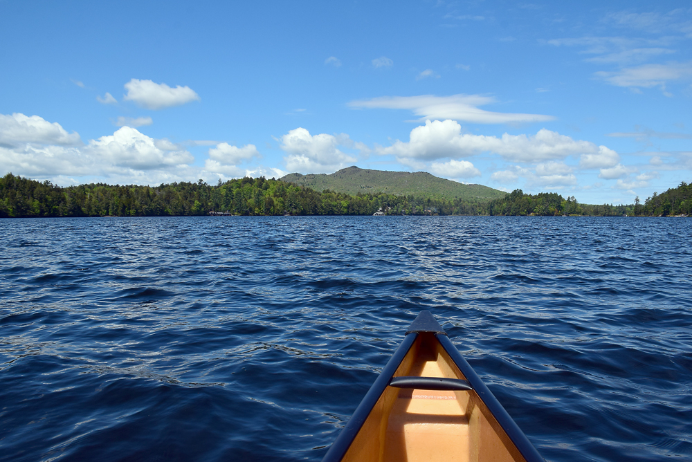
St. Regis Mountain dominates the view from Upper St. Regis Lake. (Enterprise photo — Justin A. Levine)

St. Regis Mountain dominates the view from Upper St. Regis Lake.
(Enterprise photo — Justin A. Levine)
PAUL SMITHS — We were not alone. A red eye stared at us through very thin mist and then disappeared. But it was soon back, and it had brought a friend. Or maybe a lover.
Early one morning, my friend Jason and I set out to paddle the St. Regis loop, a combination of a river, three lakes and a bit of a carry. And, sure enough, we were not alone for much of the trip as loon after loon made an appearance.
We put in on the St. Regis River off of Keese Mill Road, and began paddling upstream toward Lower St. Regis Lake and the campus of Paul Smith’s College. From the put-in, the lean-to on Peter’s Rock was an easy 2-mile paddle, and in that time we saw three pairs of loons.
Deciding it was still early, we disembarked at the lean-to to have some coffee and get our bearings. The view of the campus from Peter’s Rock — a peninsula, really — is great, and with a steady breeze there were no bugs to bug us.
This section of the paddle would make a nice out-and-back trip itself, with 4 pretty easy miles, round-trip. But we ventured on, and after rounding the point, the pleasant breeze became a headwind that necessitated backwards hats and yelling if we wanted to talk at all.
It wasn’t very far on the open water on the lower lake from the point to the wetland we aimed for, and soon the marsh bushes and winding waterway protected us from the wind. Making our way through the slough, we watched a bald eagle sail overhead and Canada geese float in the water.
At the 4-mile mark, we entered Spitfire Lake, famous not because of its cool name but because Dr. E. L. Trudeau performed tuberculosis experiments on a tiny spit of land now named Rabbit Island.
We hit a heavy headwind coming into Spitfire, and after a few minutes of really hard paddling — there were small whitecaps on the lake from the wind — we rounded a corner as the breeze died down a bit, allowing us to notice two more loons tooling around.
In the short channel between Spitfire and Upper St. Regis Lake, another of the black and white birds leisurely dove and fished as we made our way past.
We came out onto Upper St. Regis Lake, and the wind stayed in our faces. It was one of those paddling days when no matter what direction we paddled, the wind seemed to be in our faces. It wasn’t as bad out of the bigger lake, though, so we cut across to the southern shore of the lake.
Paddling along the shore, we cut in between Ward Island and into Spring Bay, taking out at the trailhead for St. Regis Mountain.
The mountain, which is home to a newly restored fire tower, has a main hiking trail that begins off of Keese Mill Road, not far from where our paddle began. But there is this second trail that is boat-access only. This trail goes up from the lake following blue state Department of Environmental Conservation trail markers.
If you’re so inclined, you can follow the trail 2.2 miles to the summit as the lake trail meets up with the main trail after about a mile.
Although Jason and I didn’t climb St. Regis, we did make the quick 0.3-mile hike to the shore of the southern Spectacle Ponds. While not much of a hike, it was nice to get out of the boat and stretch our legs for a little bit. We saw three more loons on the Upper lake, including one on a nest. We stayed well clear of her so she wouldn’t be disturbed.
Continuing on in the canoe, we headed north and found the takeout at the end of Upper St. Regis Lake at the 7.75-mile mark. We’d be on land for the rest of the trip.
Taking out at the lake, Jason shouldered the lightweight canoe and I grabbed our bags and paddles. A few hundred feet up the trail, Marvin Pond sits off to the right. It was pretty, but also pretty small, and didn’t seem worth paddling.
We continued on up a hill and then began an immediate descent down the other side. At 8 miles, we hit the road that led to the private Camp Topridge and hung a right, making our way back toward Keese Mill Road.
We passed the main trailhead for St. Regis Mountain and made it back to the cars in no time.
The carry at the end of this paddle, at three-quarters of a mile, is daunting, and would be tough with a heavy boat. But the option to go to Peter’s Rock, or into Spitfire and back, offers a couple of nice options for those who want to avoid walking so much on a paddling trip.