Tricky trail conditions as thaw sets in
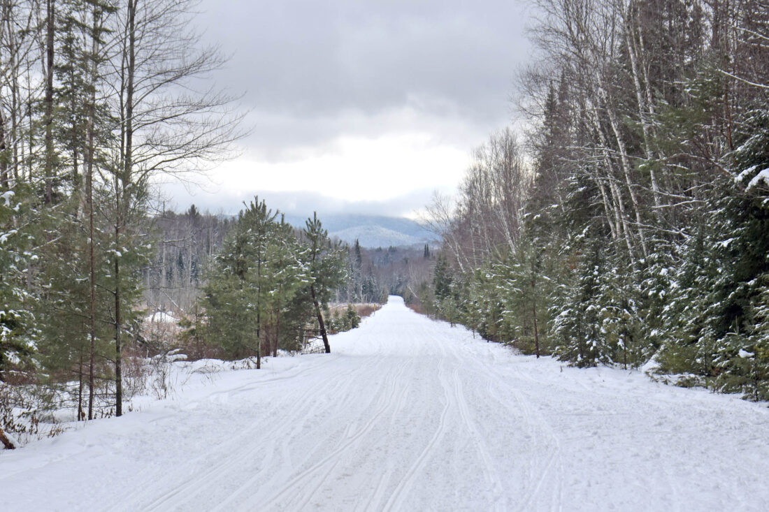
The Adirondack Rail Trail, with the snow starting to soften as temperatures climb above freezing, is seen near Fowler’s Crossing in the town of North Elba on Thursday. (Enterprise photo — Chris Gaige)
LAKE PLACID — As a January thaw sets in across the region today and Saturday, local outdoors experts are urging those venturing onto area trails to prepare for especially difficult winter conditions, and in the case of the Adirondack Rail Trail, consider staying off of it altogether until colder temperatures return later on Saturday.
The National Weather Service’s Burlington, Vermont office, which serves the Tri-Lakes region, is predicting that gusty winds will accompany the warm-up, with a high wind advisory in effect for Franklin and western Clinton counties from 10 a.m. today through 1 a.m. Saturday. NWS Burlington is forecasting sustained southeast winds between 15 and 25 mph, with gusts up to 50 mph.
The wind advisory is current as of press time Thursday, and may be subject to change, both in terms of its coverage area and duration. NWS Burlington Lead Meteorologist Marvin Boyd said that this thaw will have factors that both limit, and accelerate snowmelt. The result is a draw of sorts, where there will be some snow melting and rivers rising, but it won’t be a blockbuster thaw, and river flooding isn’t expected locally.
Boyd said the factors serving to mitigate the melt include the current hefty snowpack that will absorb some of the melting liquid, rather than having it all leech into waterways. Additionally, peak temperatures aren’t especially warm — the mid 40s — and there’s not a lot of rain predicted — about a quarter of an inch or less, which is expected to fall intermittently throughout the daytime hours today.
“Not a ton of precipitation,” he said. “That’ll definitely help keep the snow around.”
Boyd cautioned that with tonight and Saturday’s overnight low temperatures expected to fall below freezing, black ice will likely develop on any untreated surfaces that were wet during the daytime.
“We’ll have a freeze-thaw instead of just a big thaw period,” he said. “There’s going to be wet stuff, and if it refreezes, that’s when some of the untreated surfaces can become extremely slick.”
On the other hand, the factors present today and on Saturday that will increase the snowmelt rate include forecasted strong winds and high dew points, according to Boyd.
“I’d say that’s probably the biggest thing,” he said. “The wind coupled with dew points … up to 38 (degrees). That’s what’s really going to be accelerating some of the snow melt.”
Boyd said this expedited melting effect takes place at the molecular level. More collisions mean more melting, the same reason that hair dries faster using a blow dryer.
“If you think about just ambient air sitting there, there’s space for water molecules, but you only get a few collisions,” he said. “When you have wind, you are just increasing those collisions and those drier air particles are going to moisten and then leave, instead of just moistening and just sit right over the top of the snow.”
–
Adirondack Rail Trail
–
Adirondack Rail Trail Association Executive Director Julia Goren said that the organization, in conjunction with local snowmobile associations, is encouraging people to stay off the rail trail until below-freezing temperatures return later on Saturday, and the snow firms back up. This request pertains to all forms of use, including snowmobilers, skiers, snowshoers and fat tire bikers.
“With the soft snow and then the later freeze, any ruts that are created by somebody sinking into the slush are going to set up,” she said. “They’re going to be really hard for the groomers to smooth out. Anything that’s on the trail (today) is likely to set up a lasting rut that will be there for quite a while.”
With no subsequent thaw in the foreseeable future after temperatures cool later Saturday, Goren said any trail damage will likely be frozen in place for an extended duration. This played a big part in the groups’ request to potential trail users, even as the trail isn’t formally closed. With today’s rain and wind, Goren had another reason to stay off the trail.
“It’s going to be gross out there,” she said. “It’s not going to be a really pleasant time to be riding on the trail. Being out in 40 degrees and rain sets you up for problems with hypothermia as well.”
–
Mountain trails
–
Those planning on venturing into the backcountry today and into the weekend should be prepared for sloppy trail conditions, and elevated water levels, potentially making for treacherous stream and river crossings, according to Sam Fairchild, who was staffing the Adirondack Mountain Club’s (ADK) High Peaks Information Center on Thursday. He said conditions then were already starting to change.
“Things are starting to soften up, and, of course, they’re going to continue to get much softer with the impending warm and the rain,” he said. “Things are going to be very post-hole prone so it’s going to be all-the-more imperative that folks wear snowshoes if they head out at all.”
Located at its Heart Lake property, ADK’s High Peaks Information Center offers some of the most up-to-date reports sourced from first-hand accounts from the backcountry. It’s located across the parking lot from one of the busiest trailheads in the High Peaks, with routes branching off to Mount Marcy, Mount Colden and Algonquin Peak, among a myriad of other mountains and backcountry destinations.
Even though this thaw isn’t expected to cause any flooding concerns for the region’s larger rivers, the tributaries and streams in the backcountry are another matter. Both having smaller creek beds and being more proximate to where the bulk of the melting could occur — as winds pound the higher mountain slopes — tends to make these water crossings more reactive, quickly surging in flow during the event.
Fairchild said many crossings that were viable earlier this week likely aren’t any longer. This is especially dangerous when there may be earlier tracks giving the appearance of stability, when in reality, the underlying snow or ice is dangerously thin, hollowed out from running water beneath.
ADK’s High Peaks Information Center has received several reports of people punching through the ice this week.
“Water crossings are going to be a big concern with this warmup and rain,” he said.
Fairchild added that even when water levels retreat after temperatures cool off, the water crossings will still be tenuous. The previously-elevated water would have likely washed away snow and ice bridges, and those will take some additional time to build back up, especially on the larger streams in the backcountry.
Once things cool back down, Fairchild said conditions will likely be icy and crusty, and to plan accordingly.
“Things will get super crusty, so it’s going to be really important that folks are wearing snowshoes with more aggressive traction if they’re heading into the High Peaks Wilderness, or even lower-elevation trails outside the High Peaks.”
State law requires snowshoes or skis to be worn in the High Peaks Wilderness at all times when the snow depth alongside the trail exceeds 8 inches. This is to prevent post-holing, where deep boot prints can make for a hazardous trail. People found to be in violation can be ticketed by state Department of Environmental Conservation forest rangers and face a fine of up to $250.
Fairchild said that after the thaw, the snow depth could be variable, and some lower elevations could have less snow, potentially making microspikes or crampons a better means of traction. If someone doesn’t know the trail conditions in advance or is embarking on a trail that will see conditions change with elevation, Fairchild said the best course of action is to pack different traction devices and be prepared for all of the above.
Local News

Costume craziness at BrewSki
Forest ranger recalls saving hiker lost for two days in Dix Range

Back-to-back champions

LPHS to host concussion seminar Wednesday
Weekend roller coaster as mid-March warm-up looms
SARANAC LAKE — You might want to keep a few different coat options handy this weekend. A hallmark of the ...