Tri-Lakes on northern edge of powerful storm
Preliminary forecast has modest accumulations expected locally, heaviest snow to the south Sunday night and Monday
-
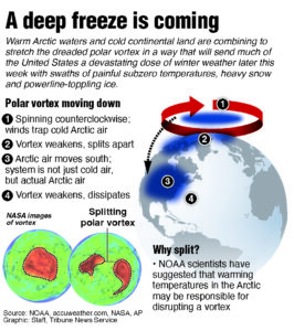
- Graphic showing how a Polar Vortex forms.
-
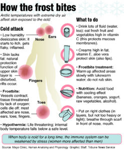
- Graphic showing how frostbite affects exposed skin, and ways to prevent it.
-

- Graphic showing the amount of time it takes to get frostbite from the outside temperature combined with the wind.

Graphic showing how a Polar Vortex forms.
SARANAC LAKE — A sprawling storm that’s put more than 180 million Americans under some sort of winter weather alert is expected to turn into a nor’easter and impact the Tri-Lakes region Sunday night and Monday.
Its effects locally, however, are still largely up in the air. Those will also likely be less dramatic than in the Central Plains, Mid-Atlantic and southern New England, which are expected to be closer to the storm’s bullseye.
The storm’s current projected track puts the Tri-Lakes on the northern periphery of steady snowfall. If the storm’s center were to move further north, snowfall forecasts could increase, and if it moves south, those would decrease. Either remains a distinct possibility as of press time Thursday, according to the National Weather Service’s Burlington, Vermont office, which serves the area.
“We’re still on that northern fence on whether we get plowable snow, or much more or even less,” NWS Burlington Meteorologist Scott Whittier said. “The probability of seeing 7 or 8 inches in the Tri-Lakes region is about 50 to 70%.”
He added that the computer model trends Wednesday night and Thursday morning have been steadily shifting the heavier snow closer to the region, but it’s still too early to bank on those, and the trend still has plenty of time to either continue or reverse itself.
Graphic showing how frostbite affects exposed skin, and ways to prevent it.
Models, as of Thursday afternoon, depicted the heaviest snowfall axis across Pennsylvania, southeastern New York and southern New England, with 16 to 24 inches possible there. That, however, is subject to change.
This storm has been grabbing national headlines, not just for delivering significant wintery weather much further south than is normal, even in winter, but for its sheer size. Winter storm watches, warnings and advisories stretch from Arizona to Massachusetts, as of press time Thursday, and are likely to expand further eastward as the storm progresses.
It’s also proved to be an especially difficult storm to predict.
Unlike Saturday’s Arctic air, which forecasting models had locked on to well in advance, this storm’s projected track has been anything but stable. That’s because the ultra-cold weather stems from one large air mass, which tends to move in more large-scale and predictable patterns. This nor’easter, on the other hand, is driven by the interaction between several different air masses, leading to more complexity and uncertainty in its movements.
It also has a sharp gradient in its impact — snowfall amounts — compared to much more general gradient in temperatures associated with the Arctic outbreak. In other words, a small shift in the storm track could spell a big difference in the amount of snow that falls, whereas a small shift in Saturday’s Arctic air mass wouldn’t change temperatures all that much.
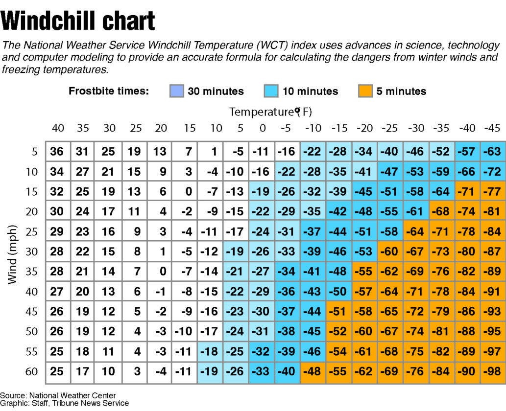
Graphic showing the amount of time it takes to get frostbite from the outside temperature combined with the wind.
The two weather events are, however, very much related. Saturday’s cold air, and its movements, will play a large part in controlling where Sunday night’s snowstorm tracks.
Whittier said that cold air is dry air, and it’s helpful to think of the core of the cold as a shield deflecting the incoming snow. The more readily the frigid cold retreats back to the north later Saturday and Sunday, the further north this snowstorm will come. Conversely, if the core of the cold were to more stubbornly remain in place, the bulk of the snow would pass southeast of the Tri-Lakes, as the computer models had earlier indicated.
“The question is, at some point, does it stop making that northern track?” he said. “As we get closer, especially (today) and Saturday … we’re pretty much honing in that it’s going to not just be a ‘watch the I-95 corridor’ event, but that it is going to move into portions of the Adirondacks and Vermont as well.”
Local News
Tri-Lakes on northern edge of powerful storm
Parks, trails, historic sites, public lands partners awarded $2.25M
ALBANY — The New York State Office of Parks, Recreation and Historic Preservation announces $2.25 million in ...
Wedding planners sound off on Lake Placid noise curfew
LAKE PLACID — Around two dozen people attended a public information session held by the town of North Elba and ...

Saranac Lake Dems choose Trudeau, Evans for trustee
Saranac Lake Dems choose Brunette to run for mayor
