Dangerous Arctic outbreak expected this weekend
Wind chill values as low as 40 below predicted; people cautioned to minimize their time outdoors
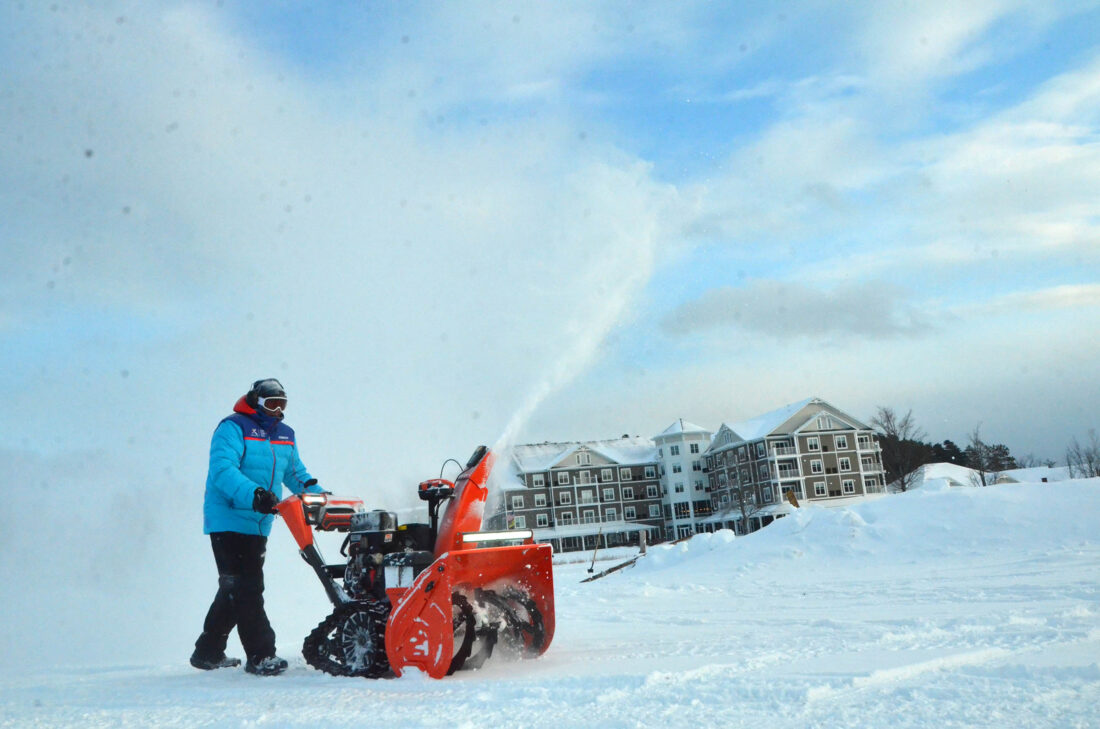
Larry Sweeney returns from snowblowing the ice field where the Ice Palace Workers will begin cutting blocks for the Saranac Lake Winter Carnival Ice Palace today. The winter’s been generous so far, giving the IPW 101 a starting ice depth of 12 inches. This is expected to grow deeper with the extreme cold temperatures this week. It’s predicted to be so cold on Saturday — with highs still in the negatives — that IPW 101 Director Joe Plumb is considering having the volunteers take the day off. (Enterprise photo — Aaron Marbone)
SARANAC LAKE — While Tuesday’s single-digit highs and sub-zero wind chills were nothing to scoff at, those were just the beginning.
An even stronger Arctic air mass is slated to set up shop over the region this weekend, delivering what is forecasted to be the coldest temperatures of the season so far.
Highs on Saturday are not expected to get above zero, while overnight lows on Friday and Saturday nights could approach 20 below, according to the National Weather Service’s Burlington, Vermont office, which serves the Tri-Lakes region.
After a seasonable day on Thursday with highs in the mid 20s, NWS Burlington Meteorologist Seth Kutikoff said an Arctic cold front is expected to cross the region early Friday, and temperatures will get colder as the day goes on. The front may be accompanied by snow squalls — brief periods of heavy snow — and gusty winds, which could reduce visibility and make for some tricky travel at times.
It is forecasted to remain breezy behind the front, with winds gradually tapering into Saturday.
At such cold ambient air temperatures, it doesn’t take much of a breeze to make it feel markedly colder. Wind chill values for Friday and Saturday are predicted to reach as low as negative 40 degrees.
“That’s incredibly, dangerously cold,” Kutikoff said.
In those conditions, frostbite takes less than 10 minutes to set in on any exposed skin. Kutikoff warned that people should avoid spending time outdoors if at all possible, and be very prepared if they must.
It’s the coldest air mass of the winter season, so far. The core of it will be over the region Friday night and Saturday, before it starts to push east on Sunday. By the start of the work week, temperatures should moderate back to highs in the teens and overnight lows around zero, seasonable for this time of year.
“We’re not seeing anything particularly unusual for next week in terms of the cold,” Kutikoff said.
Kutikoff said that unlike storm-specific snowfall forecasts, which can be heavily swayed by subtle tweaks to a storm track and are often difficult to predict in advance, there’s more forecasting confidence in an event like this — even several days out. That’s because the air mass in question is so large, and moves in a more predictable manner, allowing computer forecasting models to lock in.
The silver lining, Kutikoff said, is that with an advanced notice, people could be able to take precautions and plan accordingly to minimize their time outdoors then. Towards the end of the week, he said NWS Burlington will likely issue cold weather alerts containing specific times when people should exercise extreme cold weather preparedness.
Common warning signs of hypothermia include confusion, shivering, slurred speech or mumbling, sleepiness, stiff muscles and, in severe cases, loss of consciousness, a weak pulse and slow, shallow breathing.
It’s important to be vigilant of those around you, as symptoms usually set in gradually, and those with hypothermia may not be aware of their condition. While anyone can be at risk for hypothermia, especially vulnerable populations include newborns, the elderly, those with chronic illnesses, outdoor workers and the unhoused people, according to the NWS.
For more tips on how to stay safe during extremely cold weather, visit weather.gov/safety/cold.
Local News
Crossing the line
Wilmington board passes set of zoning amendments

Corned beef and bowling
Having the time of their lives
Saranac Lake trustee candidates speak at forum
SARANAC LAKE – Three of the candidates running for two open village trustee seats on the March 18 ballot – ...