Paddle to a one-of-a-kind hike
-

- Brad Batty, of Redford, paddles along Turtle Pond last Saturday as Long Pond Mountain rises behind him. (Enterprise photo — Justin A. Levine)
-

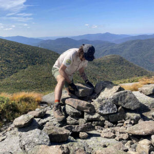
- Justin Levine nears the top of Long Pond Mountain in the St. Regis Canoe Area last Saturday. The mountain is only accessible via a canoe or kayak paddle on Long Pond. (Provided photo — Brad Batty)

Brad Batty, of Redford, paddles along Turtle Pond last Saturday as Long Pond Mountain rises behind him. (Enterprise photo — Justin A. Levine)
I honestly thought we would be all alone at the top of Long Pond Mountain, so to say I was surprised to see three other canoes at the trailhead would be an understatement.
My uncle Brad and I set out early on Saturday morning, after a breakfast of fresh eggs and bacon. We drove down to the Saranac Inn area and ditched my car at the Hoel Pond public launch so we could make our canoe/hike excursion a one-way trip.
Since the forecast had been calling for thunderstorms all week, we kept an eye on the weather and decided to try and climb the mountain first, just in case we had to bail on the rest of the paddle because of lightning.
The plan was to put in on Long Pond, paddle to and then climb Long Pond Mountain, and then head to my car via Slang, Turtle and Hoel ponds. The majority of the trip was in the St. Regis Canoe Area, with the exception of Hoel Pond.
We launched the canoe after thoroughly dousing ourselves with bug spray, and began to make our way across Long Pond.

Justin Levine nears the top of Long Pond Mountain in the St. Regis Canoe Area last Saturday. The mountain is only accessible via a canoe or kayak paddle on Long Pond. (Provided photo — Brad Batty)
This pond has earned its name for a reason, but as we made our way first east and then north, the clouds showed no signs of turning dark and dumping rain on us.
There was enough of a breeze out on the water to keep the bugs down as Brad and I caught up a little as we paddled. In well under an hour we were at the trailhead, which is only accessible via canoe or kayak.
As we pulled up on shore, there were three other canoes sitting in the shade of the woods. We pulled Brad’s Bell canoe up on shore and checked our packs to make sure we had everything for the relatively short hike.
Packing for a combination trip like this can be tricky, but at least Brad and I each remembered to wear hiking shoes and not flip-flops.
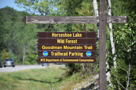
We donned our packs and headed up the trail, which is marked with both red state Department of Environmental Conservation discs and yellow canoe carry markers. The first part of the trail is a canoe carry to a little body of water called Mountain Pond. While it sure is pretty, Brad and I could not figure out why anyone would want to drag their boat that far into the woods to paddle on the very small pond. But to each his own.
Once we hit Mountain Pond, the trail took a right and the yellow markers disappeared. While it seemed like this trail was recently marked, there were definitely some old trail markers hanging on in various spots. This was reasurring because I had found a description of the trip that said it was an unmarked trail. Not a deal breaker for us, but following a marked trail is a heck of a lot easier than bushwhacking.
The first half of the climb was essentially flat, but the trail soon began to climb steadily. Based on the few reports of this hike I had read, I was expecting a rarely visited, hard-to-follow trail, but that was far from the case.
The trail is well trod and marked, and despite the little spots of red steadily appearing on our shins from the black flies, we enjoyed the short hike, which was about 1.5 miles up.
Gaining the top of the mountain on some exposed bedrock, Brad and I turned around to see the rest of our trip laid out before us. We could see the eastern arm of Long Pond, and then stretching into the distance, displayed as if just for us, were Slang, Turtle and Hoel Ponds.
In the distance we could see the carved out slopes of Big Tupper Ski Area, and even with the humid haze graying the sky a little bit, the clouds were high and did not obstruct our views.
As we took in the scenery, Brad and I noticed we were alone at the top, despite the canoes we saw at the trailhead. Brad looked around and found a small herd path leading away from the direction we had come, so we walked the path and came out on the other side of the summit just a few hundred yards away.
As we emerged from the thickly vegetated middle of the summit, more stunning views met us, as did the laughter and talk of a half-dozen people sitting there enjoying the day.
We chatted with the assembled crowd, and turned down their generous offer of some wine (it was 10:30 a.m. and we still had a way to go, but the offer was certainly appreciated).
Brad and I went back to the other side of the mountain to sit in some shade and have a bite to eat. On our way back down to the canoe, we came across another group of four, and then another pair who talked to us extensively, all because they noticed Brad was wearing a Bob Marley shirt.
After we relaunched the canoe, we faced a gentle headwind on our paddle east to the carry to Slang Pond. We paddled Slang, again fighting a bit of a headwind, and then managed to get the canoe through a small, rocky stream that flows from Turtle Pond into Slang. In other years when we haven’t had as much rain, this little stream would be unpaddleable. As it was, Brad’s canoe probably endured a couple of new scratches in the 50-foot long stream.
We took a break just across Turtle Pond from where we had entered and ate lunch. I personally took inventory of the small bloody spots dotting my legs, and decided that was a problem I would just have to deal with when I got home. We were having too much fun to let a few blood suckers ruin it.
After a bite to eat, we again set out in the boat, and, again, faced a stiffening headwind. The headwind was surprising because at this point we had paddled east, west, north and south and had faced a breeze the entire time.
We quickly reached the carry to Hoel Pond, which was the shortest of the day. The carry itself is maybe 100 feet, but it’s steep because it goes up and over the railroad tracks of the Remsen-Lake Placid Travel Corridor.
Once on Hoel Pond, the wind was serious. We had to paddle hard to make our way across, and there were no chances to stop to just linger and take some photos.
However, once we were close to our final take-out, the trees and land gave us a bit of a wind break. We spun the canoe around and took in the stunning views. Not only is Hoel Pond beautiful, but in the distance we could clearly see Long Pond Mountain, and just off to the side we could make out the newly refurbished fire tower on St. Regis Mountain.
Sitting in the canoe, looking at where we had come from, the bug bites dotting our legs didn’t even register. Brad and I sat there in silence for a few minutes and just soaked in the view. The forecast had been wrong, and this soaking was the only one we were subjected to all day. And that was more than alright with us.
—
Long Pond Mountain
Activity: Paddling/hiking
Difficulty: Moderate
Distance: 10.4 miles
Directions: From Saranac Lake, take state Route 86 toward Paul Smiths. Turn left on state route 186, and go 8.8 miles to Floodwood Rd. on the right. Take Floodwood Rd. 0.4 miles and bear left, then go another 4.6 miles to the Long Pond parking area on the right. To do a one-way trip, leave a car at the Hoel Pond launch. This could also be a nice out-and-back trip from Long Pond.