Wildfire effects hit North Country
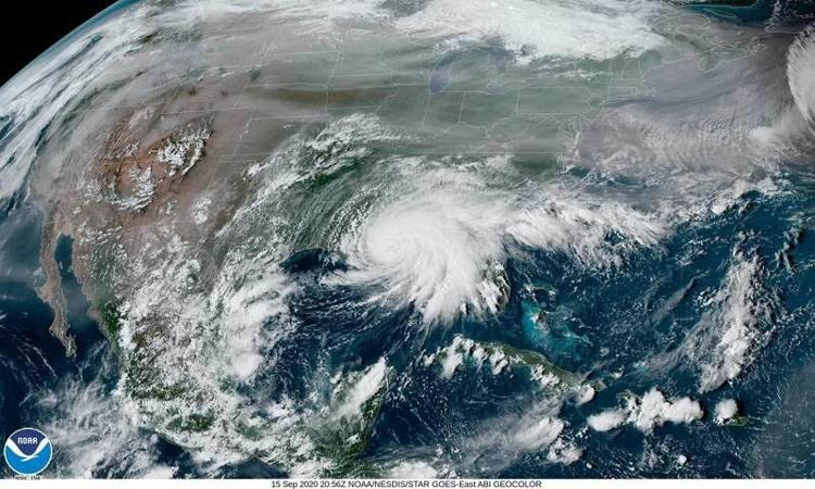
The National Weather Service in Burlington, Vermont, described this NOAA image as “impressive satellite imagery to look at this afternoon with smoke from western wildfires clearly visible across the central and northern (United States), while Hurricane Sally is making landfall on the southern coast.”
The impact of the western wildfires is not limited to the Pacific coast.
“The jet stream is transporting the smoke from California out west into New England,” said Andrea LaRocca, National Weather Service meteorologist.
“It’s probably above 15,000 feet. It’s fairly high up in the air. That’s really the gist of it.”
–
The jet stream
–
The jet stream is a group of strong air currents that travel in paths around the globe.
“And it’s that mechanism that is moving the smoke,” she said.
“We’ve been seeing smoke in the area on and off for a week now, but what is most important is whether or not we have high pressure or low pressure and how that affects the visibility of it.”
–
Hanging around
–
Low-pressure clouds can obstruct viewing the smoke.
“But on a day like today when it’s clear and there’s no clouds, the smoke is much more visible,” LaRocca said.
A forecast run from a model gives a general idea of how long the smoke will remain over the area.
“It looks like we’re looking at least some amount of smoke in the area really through Thursday morning, maybe into the afternoon hours,” she said.
“But behind that I can see on this model that kind of starts to clear out to our east. So by Friday, we shouldn’t have the influence of the smoke aloft anymore. That’s not to mean it can’t come back, you know. The weather is ever changing. But for that period of time, the winds will be in a favorable direction that we won’t be bringing in the smoke aloft.”
–
Smoke being carried
–
Hurricane Sally is another jet stream event that will make landfall by 1 p.m. on Wednesday.
“That’s going to stay well to our south,” LaRocca said.
National Oceanic and Atmospheric Administration satellite imagery captured both weather phenomena.
“This is a beautiful image,” she said.
“You can see the hurricane kind of right dead in the center. All that milkiness that you see just above it to the north, you can see it out across the west, all across the Northern Plains and the Great Lakes and over New England; that is all smoke being carried. It’s very distinct from the clouds that you see.”
Local News
Sinfonietta plans Midsummer Gala for Aug. 1
LAKE PLACID — Tickets are still available for the Lake Placid Sinfonietta’s “Midsummer Gala” at 6 p.m. ...

Lifeguard learning

After assistant forest ranger’s death, friends call for DEC reforms
Outdoorsman, educator, historian, friend

Sharing cycling
