APA reviews plan for Sentinel Wilderness
Town will move water line for Craig Wood Golf Course
-

- Emily Lyons of New York City jumps from one of the Balanced Rocks to the other on Pitchoff Mountain, in the Sentinel Range Wilderness Area between Lake Placid and Keene. (Enterprise photo — Antonio Olivero)
-
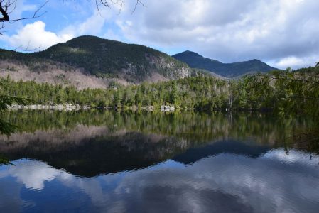
- Whiteface Mountain looms over the still waters of Copperas Pond in the Sentinel Range Wilderness Area near Lake Placid earlier this year. (Enterprise photo — Justin A. Levine)
-

- The trailhead of the Old Mountain Road trail has a sign about ice climbing. Ice climbers frequent the cliffs on the back side of Pitchoff Mountain, accessible from this trail. (Enterprise photo — Justin A. Levine)

Emily Lyons of New York City jumps from one of the Balanced Rocks to the other on Pitchoff Mountain, in the Sentinel Range Wilderness Area between Lake Placid and Keene. (Enterprise photo — Antonio Olivero)
RAY BROOK — The state Department of Environmental Conservation has released its unit management plan for the Sentinel Range Wilderness Area near Lake Placid, and the state Adirondack Park Agency is poised to approve a public comment period for the plan later this week.
The Sentinel Range Wilderness covers just shy of 24,000 acres in the towns of Jay, North Elba and Wilmington, and is bounded by state routes 73 and 86 as well as some local roads. It is home to several popular destinations, including a section of the Jackrabbit Ski Trail, Pitchoff Mountain — both the hiking trail and numerous climbing routes — and Owen and Copperas ponds.
The DEC began the planning process two years ago and released its final draft earlier this month. Before the UMP can be implemented, it needs to go through DEC and APA public comment periods. The plan also has plans for a related primitive area that bisects the Sentinel Range Wilderness along Bartlett Road.
–
Boundary lines

Whiteface Mountain looms over the still waters of Copperas Pond in the Sentinel Range Wilderness Area near Lake Placid earlier this year. (Enterprise photo — Justin A. Levine)
–
The UMP says that, in addition to roads that form boundaries, there are about 26 miles of boundary line ringing the Sentinel Range Wilderness. The plan calls on DEC staff to mark and paint the boundaries.
It also says there is at least one known encroachment on this state land.
“This is a waterline that runs from the Town of North Elba’s Craig Wood Golf Course onto State Forest Preserve land for a distance of about one mile,” the UMP says. “The waterline ends at a small impoundment on State land at a tributary of Roaring Brook. It is not certain what year the water line was established, but it is believed that it dates to at least the early 1930s. The waterline and impoundment are on a parcel of lands that has been in State ownership since 1881. At this point no documentation has been found to show the Town of North Elba has a legal right for a waterline to be located on State land.”
The UMP says this encroachment should be resolved within three years of adopting the plan.

The trailhead of the Old Mountain Road trail has a sign about ice climbing. Ice climbers frequent the cliffs on the back side of Pitchoff Mountain, accessible from this trail. (Enterprise photo — Justin A. Levine)
Craig Wood Golf Course is owned and operated by the town of North Elba.
In a phone call Monday, North Elba Supervisor Roby Politi said the town has already found an alternative irrigation source and plans to remove the offending pipe.
“There was, in the old days, a temporary revocable permit, and it was inspected a long time ago,” Politi said. “They (the DEC) brought it to our attention about a year ago, and we would find an alternative water source, which we have done, so we’re not going to be using it anymore.
“It was an old man-made reservoir way up in the woods. It provided water for, I think, the sixth tee and the fifth green. We’ve had to increase the size of our ponds that we use on the course, so we don’t need to use it anymore.”
Politi said removal of the pipe would have no impact on the operation of the golf course.
–
Trails and parking areas
–
The UMP calls for rerouting several trails to make them more sustainable, and for formalizing three herd paths to climbing areas.
“The trails to Barkeater Cliffs, Notch Mountain, and Pitchoff Chimney Cliff will become official trails and may be upgraded where necessary,” the UMP says. The trail up Pitchoff will undergo reroutes, as will the trail to Copperas Pond. The Pitchoff trail will be rerouted to a new parking area along state Route 73, adding some distance to the trail, including a roughly 0.4-mile increase from the road to Balanced Rocks Overlook.
The UMP also calls for 10,500 acres to remain trail-free, which should be a boon to hunters.
“The central area of the SRWA will be managed as an area without developed trails,” the UMP says. “The purpose for this is to facilitate recreation opportunities of an undeveloped nature and to preserve an area that has comparatively lower levels of human impacts.
“The trailless area will include the summits of Stewart, Kilburn, Slide, and Black mountains. Herd paths in the area may remain, provided the use of the paths do not result in significant damage to the natural resources. The herd paths will not be improved or maintained.”
The UMP also calls for rerouting parts of the Jackrabbit Ski Trail due to drainage issues along Old Mountain Road.
Public comment asked the DEC to reopen historic ski trails that were used in the 1932 Winter Olympics, but the department said those trails will remain closed.
The DEC plans to build a larger parking area for the Jackrabbit on Mountain Lane and will construct a new parking area along Route 73 for the Pitchoff Mountain trail.
–
Camping
–
The UMP calls for the closure of several backcountry campsites but offsets those closures with new sites.
Two of the campsites at Copperas Pond will be closed while a new one will be built in another location. The campsite at Holcomb Pond will be closed. The DEC says so few people go to it now that it will not be replaced.
The UMP also calls for the construction of two new campsites along Bartlett Road, though neither will be accessible by car. Camping will also be prohibited above 3,500 feet in elevation.
The lone lean-to within the SRWA is located at Copperas Pond, but it is well within the recommended 100-foot setback from the water’s edge. Due to this, the DEC will cease maintenance of the lean-to, and once it is determined to be unsafe, a new lean-to will be constructed at a site that complies with Adirondack Park State Land Master Plan guidance on campsites.
–
Climbing
–
There are more than a dozen climbing routes within the Sentinel Range Wilderness, some of which have fixed anchors, which are illegal under state law. The UMP calls for the formation of a focus group to discuss the impact and possible solutions to fixed anchors.
The UMP will come before the APA board on Friday. The board will vote to send the plan out for public comment on its conformance with the Adirondack Park State Land Master Plan.
To view the full UMP, go to www.dec.ny.gov/lands/22589.html.
Local News

Aloha Spirit: Tupper Lake Field Day returns Saturday
Lake Placid Airport granted $425K from FAA
LAKE PLACID — The Lake Placid Airport is one of four North Country airports to receive grants from the Federal ...

John Gereau named ADE, LPN publisher
Tupper Lake Lions Club celebrates 90 years
TUPPER LAKE — The Tupper Lake Lions Club is approaching its 90th anniversary. The club was established on Aug. ...
Authentic Adirondackers sought for roles in film
SARANAC LAKE — Casting for a feature film set in the Adirondacks is underway, with a casting director putting ...
